
Manhattan Neighbor Records by Block
For the immediate area around an address, maps and parcel records provide the clearest public starting point. NYC Planning maps can show the tax lot and surrounding lot pattern. Department of Finance records add an account or owner name and property data for a selected parcel. ACRIS adds recorded-document parties and legal descriptions. Building and condition systems describe filings and agency actions, not a complete household. The result is a block record trail, not a directory of everyone who lives nearby.
| Source | What It Shows About a Block | Access Route |
|---|---|---|
| ZoLa and NYC Map | Parcel geometry, adjacent lots, zoning, districts, landmarks, and community-board context | Free map with search, pan, click, and layer controls |
| PAD and Digital Tax Map | BBL, lot, address, blockface, condo, billing, interior, and vacant-lot indicators | Planning data and map resources |
| DOF Property Information Portal | Account or owner name, value and class fields, and mailing versus situs address | Search by address, BBL, or borough and block |
| ACRIS | Recorded parties, deeds, legal descriptions, and related document details | Online from 1966; older City Register research |
| DOB BIS and DOB NOW | Building profiles, permits, filings, complaints, violations, and occupancy records | Separate public search systems |
| Community Boards | Neighborhood coverage, public meetings, civic contacts, and issue records | City board pages and meetings |
Ownership, account mail, and actual presence are different facts. A tax mailing address can belong to an agent, lender, business, trust, or managing office. A recorded party is linked to a document, not automatically to a current unit. This distinction is especially important on Manhattan blocks, where one lot can contain several addresses and a single building can have many entrances or unit tax lots.
Note: Keep the parcel’s situs and mailing labels separate, because the public account record can identify an administrative contact rather than a person onsite.
Manhattan Parcel Layers for Neighbor Research
A Manhattan BBL is the bridge between a street address and the block’s official record systems. It combines borough, block, and lot. Manhattan’s borough code is 1, and a padded BBL can be carried from the Department of Finance portal to ACRIS, DOB, and the map layers. The address is a location label. The BBL identifies the tax lot. A BIN identifies the building. Keeping those keys separate prevents a large building or a shared lot from being counted more than once.
The NYC GIS search documentation illustrates address, BBL, intersection, and blockface search options used to establish the parcel before researching nearby lots.
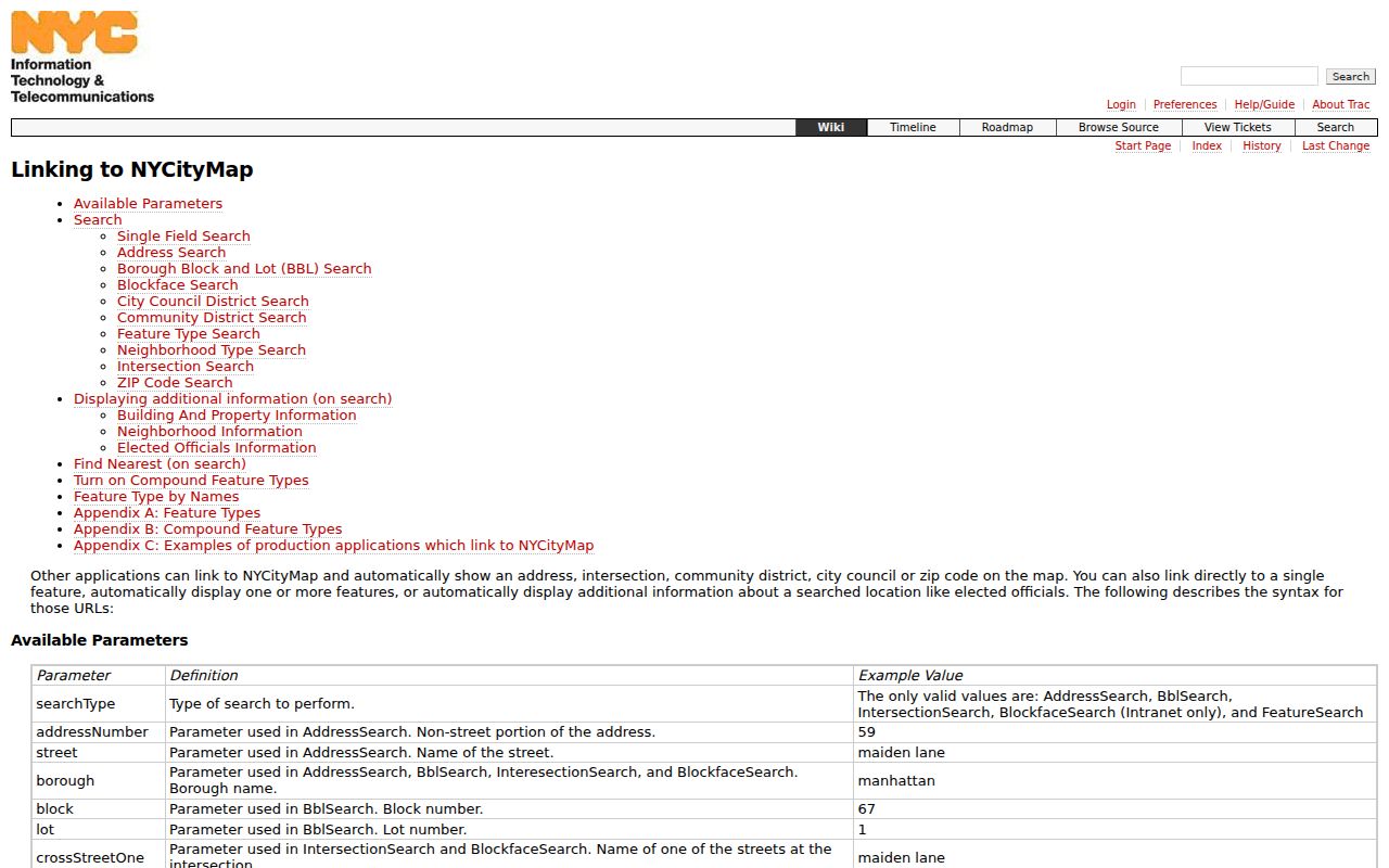
Use the documented address and BBL controls to get the parcel key first, then inspect surrounding lots in the map rather than treating a street label as a complete block boundary.
| Address search | Enter an address, intersection, or common place name to obtain property candidates and verify the BBL. |
|---|---|
| BBL search | Enter borough, block, and lot for the exact tax lot, the strongest key for ACRIS, DOB, and map work. |
| Borough and block | Use the borough and block controls to browse parcels across a wider tax block. |
| Map search | Search by BBL, BIN, or address, then pan, click parcels, and turn on planning or district layers. |
| Blockface search | Use a blockface when the question is one side of one street; a tax-block view is wider and includes lots on all sides. |
Condominiums and co-ops need extra care. A building can have separate unit lots and a billing BBL, while the billing address may be an administrative address for the larger development. A single BIN and address list can help connect multiple entrances to one structure. No one field should be used as an assumption about the people inside.
Mapping a Manhattan Block by Parcel
Use the map to move outward from one known address in a controlled way. The process creates a small, source-labeled inventory of adjacent lots rather than a claim that every listed record belongs to a neighbor. Parcel clicks show the geometry. Department of Finance and City Register results explain the property record. DOB and HPD can add building context. This sequence works well when cross streets or a blockface are known.
- Search the address in the Department of Finance portal or ACRIS and record the BBL, situs address, and any BIN shown.
- Open the address or BBL in ZoLa, then use parcel click and pan controls to identify touching lots.
- Label each adjacent lot by compass direction or cross street, retaining its address and BBL rather than guessing from a building name.
- Search each BBL in DOF and ACRIS. Note the account or owner field, recent recorded-document party, legal description, and whether an address is situs or mailing.
- Use BIN, BIS, DOB NOW, or HPD only to add building facts. For a full named-street record trail, use the Manhattan street directory.
This process also exposes limits. Lots may merge or divide, an interior lot may not face the street, and a document can cover multiple parcels. Follow the legal description and BBL references when the street label differs from the map.
Manhattan Voter Rules for Neighbor Research
New York’s public voter tool is intentionally not a block list. It requires a person’s first name, last name, birth date, borough, and ZIP, entered as the registration record holds them. The response is an exact confirmation or a not-found result. It cannot be used to browse everyone at an address or on a block. A not-found response can reflect an incorrect exact input, a change of address, inactive status, or a confidential record.
Full voter-file access is also controlled. Election Law §3-103(5) requires an elections-purpose statement for voter-registration data, and confidential participants are not ordinary block data. Poll-site streetfinder material can associate a house number with an election or assembly district, but it is not a substitute for a roster of neighbors. Use the Board of Elections channel for election administration, and keep the result within its lawful purpose.
For public civic contacts, the Manhattan Board of Elections is at 200 Varick Street, 10th floor, and lists 212-886-2100. This office is a proper fallback for registration questions, not an alternate route around the exact-match limits.
Note: A protected or not-found registration result must not be treated as evidence that a person is absent from the block.
Manhattan Community Contacts for Neighbors
The City’s twelve community boards are the safest public community layer because they are civic bodies with offices, meetings, and neighborhood coverage. They do not stand in for private membership lists. Community Board 3 and Community Board 4 publish unusually detailed public group information, including block-association coverage and contacts in some areas. Contact a board to follow a public meeting or identify a civic resource, not to assume that a listed person represents everyone on a block.
Community Board 1
Tribeca, Seaport/Civic Center, Financial District, and Battery Park City.
1 Centre Street, Room 2202-N
212-669-7970
Community Board 3
Tompkins Square, East Village, Lower East Side, Chinatown, and Two Bridges. Its public groups list includes named block associations.
59 East 4th Street
212-533-5300
Community Board 4
Chelsea and Clinton/Hell’s Kitchen. Its public inventory includes block and neighborhood groups by street coverage.
424 West 33rd Street
212-736-4536
Community Board 12
Washington Heights and Inwood, with public board contact and meeting information.
530 West 166th Street
212-568-8500
Community Board 4’s public association inventory covers named groups around West 15th through West 56th Streets, alongside larger Chelsea and Clinton organizations. Board 3’s group list includes associations in the East Village and Lower East Side. These sources publish coverage and contacts when available, not a complete record of participants or households.
Manhattan Blocks with Many Addresses
Manhattan block geography creates a practical research problem. One block can contain an apartment tower, hotel, school, hospital, office, public development, condominium unit lots, and a postal facility. A ZIP is therefore a weak identity key. The stronger combination is BBL or BIN plus the street and cross street. Map layers can also place a lot in a community district, landmark area, or planning district without identifying every person connected to it.
Address history can complicate the search further. Lower Manhattan and the Village have pre-grid streets and older deed or ward references, while other areas may have changing street numbers, changing neighborhood labels, or lot mergers. If an old address does not match the current map, compare historical maps, cross streets, legal descriptions, and BBL references. Do not force an old street label onto a current parcel without a record that bridges the change.
Note: A mailing address, legal description, and situs address can point to different things, so retain the label that each public system uses.
Official and Commercial Neighbor Results
Official sources and commercial neighbor products answer different questions. Official records are tied to a custodian and a defined record purpose. Commercial products are an industry category that may combine address fragments, claimed relationships, marketing data, and stale public-record associations. They can be incomplete or wrong and should not replace the parcel, deed, GIS, or voter rules that apply in Manhattan.
| Official block record | Commercial neighbor product |
|---|---|
| Shows a specific parcel, document, building filing, or public civic contact with its government or public custodian. | May combine fragments from different dates and sources, without making the original record easy to verify. |
| Uses BBL, BIN, case, or document identifiers that can be checked with the holder. | Can duplicate people, conflate names, or associate an old address with a person. |
| Respects voter, sealed-record, and confidentiality limits built into the access channel. | Cannot authorize bypassing protected records or private building information. |
When the fact matters, return to the property, court, election, or archive custodian. A paid profile is not a certified deed, an official court file, a voter confirmation, or a public map record.
Privacy Boundaries for a Neighbor Lookup
Some information remains private even where parcel data is public. Utility and delivery records, private building and community rosters, protected voter information, sealed court matters, and the details of confidential participants are not open block data. The absence of a person from a parcel or public-record result does not establish that the person is absent from the area.
The New York Address Confidentiality Program provides a substitute address and mail forwarding for eligible participants under Executive Law §108. New York also has a confidential-voter procedure. Agencies must protect the actual location unless an authorized exception applies. Never use a public address to follow, contact repeatedly, threaten, or evade a confidentiality program.
Lawful use. Use Manhattan neighbor research for personal, civic, family-history, or safety purposes. Do not use it to stalk, harass, intimidate, impersonate, or expose a protected person.
Past Residents Around Manhattan Blocks
Historic context belongs in archives, not guesses about a current block. NYPL Milstein holds directories, telephone books, vital indexes, census, newspapers, maps, and building-history aids, with some materials available only in person. The Municipal Archives also holds the 1890 Police Census, an address-ordered source that includes names, age, sex, and children, although it does not provide a mail-search service. These records are useful for a dated household or neighborhood history.
Newspaper notices, obituaries, probate, old directories, and maps can add time and place to an historic address. Preserve the issue, date, page, and source, then confirm material facts with the relevant custodian. A block changes over time, so a historic source should be dated before it is compared with a current parcel map.
Note: Treat an archived name as a dated record of the source, not as a claim about a present-day address.